 The route passes roughly between deep canyon walls with sparse vegetation. This canyon doesn’t appear to have very much water or riparian habitat, at least in the fall.
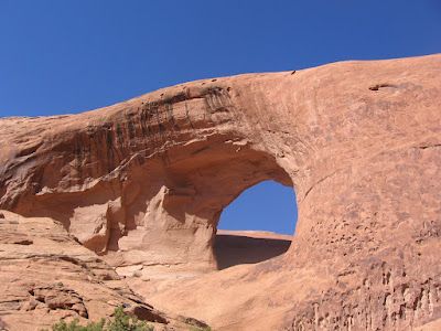
A good destination for a hiker is the large Window Arch about 3.5 miles down the trail.
 The road loops around the fin with Window Arch so it is visible from the north and the south. One of the major 4WD obstacles is on the north side of the loop with the Window looming overhead. At the 2.5 mile mark there is an east side canyon with short unmarked trail to the Troll Bridge Arch. (There is a separate post on this side trail. Use the label Troll Bridge to find.)
 Past Window Arch the road climbs to a pass where I turned around. The climb up to the pass is the last of the major 4WD obstacles. These obstacles have colorful names like Rocker Knocker, The Rock Pile, and the last one is Yellow Hill. The overall route goes about 5 miles and connects to the Behind the Rocks Jeep Trail.
 Looking back toward the area below Window Arch, the reptile looking formation that contains the Halls Bridge arch is visible. This formation is not very clear from below. There is a 0.5 mile trail leading to a good view point of the large Halls Bridge. (Separate post again .. Halls Bridge.)
 Pritchett Arch is clearly visible from the area below Window Arch on the rim to the south. There is also a formation in this area that resembles the head and neck of an ostrich.
The hiking along the Pritchett Canyon Trail is fairly easy, the grade is gradually uphill and the footing is slightly sandy. There are rocky points that are easy to hike past that look impossible for vehicles. The trail head information advises that vehicles should have 2 locking differentials, 33” or larger tires and winches.
There is a warning of high possibility of roll over, breakdown and body damage. I hiked the side trail to the Troll Bridge and arrived at the Window Arch after about 2:15 hours. I continued up to the pass and then returned below and hiked the side trail to large Halls Bridge.


 Halls Bridge is a large arch but it is not facing the area where the Pritchett Canyon Trail circles around the very large Window Arch and then continues east up to a pass. The west leading side road comes to an end and a trail continues along the rim of a canyon drainage.

 The route is well marked for about 1.2 miles as it approaches an area with many conehead sandstone formations and arrives at a fenced vegetation restoration area where the main trail turns left. There is an old trail that continues north to the right toward Moab Rim Arch and Tukuhnikivista Arch.


