Tuesday, October 30, 2012

Amasa Back Trail


The Amasa Back Trail is a popular mountain bike trail along Kane Creek Road west of Moab in southeast Utah. The trailhead parking is 5.4 miles west of the junction with Highway 191. The west turn is at the McDonald's  For hikers, it is 0.5 miles of walking further east along Kane Creek Road before the trail plunges over the edge into the canyon.


The first segment of trail descends into the Kane Creek Canyon and then climbs up the south side. The length of the actual Amasa Back Trail is 3.8 miles with several options. There is an aerial photo map at the trailhead that shows the trails connected here.


The same route is also called the Cliffhanger Trail and it is a very difficult motorized trail. In the first 100 yards there is a 3 foot cliff to get past along with several other steep difficult ledges. These obstacles are all easy for hikers.


After crossing the canyon and climbing up the other side, there is a side trail to the right marked with a rock cairn that is not shown on the area maps. This side trail climbs up a drainage, crosses around the drainage head and continues up to a ledge that overlooks the first segment of trail.


There is a good petroglyph panel along the ledge that features a large featureless human figure, an owl and several mountain sheep. This panel is visible from the trailhead with binoculars.


Mountain sheep are a common image for petroglyphs but an owl is unusual. It took me about 1:00 hour to arrive here from the parking area. The route wasn't completely obvious and I spent a few minutes looking for the way up. The descent back to the main trail took 0:15 minutes. I noticed two minor panels before the main panel.


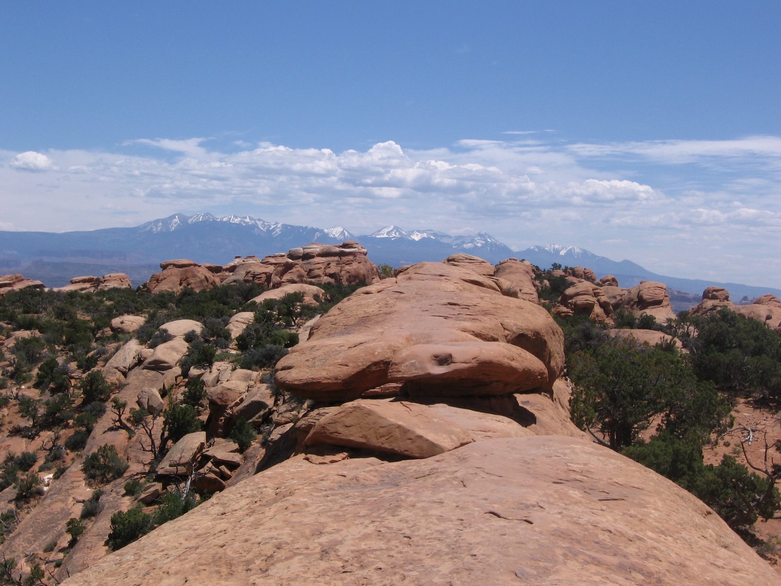
As the trail turns away from Kane Creek there are several monument type formations. The route continues to climb steadily. The desert vegetation includes scattered Pinon Pines and Utah Junipers with Black Brush and Mormon Tea shrubs.


At the higher elevations, the fins of the Behind the Rocks area become visible and the La Sal Mountains peak over the top.


After 2.0 miles on the trail, there is a side trail leading 0.7 miles northeast to a view point. The main trail leads 0.8 miles northwest to junctions with other trails, and at least 1.0 mile beyond the junction. I stopped about 0.2 miles along the side trail at a high point. It took me 2:20 hours to arrive at this point. From here, there are wide views to the north over the Colorado River and toward the Poison Spider Mesa area.


My return hike of 2.7 downhill miles to the parking area took 1:20 hours. My total hike took 3:45 hours for about 6 miles. I hiked on a 65 F degree late October day and carried 3 liters of water. I saw 8 mountain bikers during my hike and one group of motorized riders that were struggling to get started.


18407_$5 Shipping on Orders of $99 or More! 544544_$20 off any hotel booking of $350 or more with code TLSALE20

Tuesday, May 8, 2012

Sego Canyon Rock Art


The Sego Canyon Rock Art site is 4 miles north of Thompson Springs, along Interstate Highway 70 in southeast Utah. Thompson Springs is a few miles east of the junction of I-70 with Highway 191 that leads 30 miles south to Moab. Thompson Springs is a small town.

Follow the main road to the north edge where BLM signs point the rest of the way. The road is paved to the rock art site.

There are several interpretive signs at the site but in 2012 they are fading. The panel facing the parking area across a drainage is considered to have been done in historic times by the Utes. The figures include horses and riders, a white bison, large human figures, and large shields. 


The Utes practiced a hunting and gathering life style in western Colorado and eastern Utah until the 1880s when they were moved onto Reservations.


The next panel to the right is associated with the Fremont Culture that thrived from 600 to 1250 AD, the same time period as the Ancestral Pueblos of the Mesa Verde area. The red painted figures at the top are considered to be the oldest. The most eye catching are the larger pecked figures with trapezoidal bodies and heads and decorative collars. There are some mountain sheep and other animals and geometric images.


Standing back, the Fremont panel is at a right angle with a similar sized Barrier style panel. Comparing the two styles may be easier here than any other location that is easy to access. The Barrier style is attributed to the group known as Archaic. They were nomadic hunters and gatherers, living in this area from 8000 to 2000 years ago, until the introduction of corn agriculture.

This panel has at least 19 ghostly images. This panel is comparable to the Great Gallery in the Horseshoe Canyon Unit of Canyonlands National Park, the site that the Barrier style is named for.


The group in the middle is the most eye catching. They show the hollow eyes and antennae or horns that seem puzzling to us now.


They mostly seem to have their arms folded in front of their chests. This is probably the best rock art site in the Moab region that is easy to access.


Arch enthusiasts will notice the Sego Canyon Arch on the other side of the road directly across from the main rock art panels. It is a short walk up the drainage to get under the arch. Walking up the drainage, there are some old mining related bridge structures visible. There was mining activity in Sego Canyon and perhaps a ghost town to search for.


There are more rock art panels also across the road slightly north of the Sego Canyon Arch. 


These panels are somewhat less protected than the three main panels. I visited on an early May weekend day. There were three or four other vehicles present during my visit.


528614_Russell Outdoor Logo 125x125

Thursday, April 26, 2012

Devils Garden Trail to Double O Arch


The Devils Garden Trail is one of the most popular trails in Arches National Park, near Moab in southeast Utah.  The Devils Garden Trail Head is at the north end of the paved road, about 18 miles from the Visitor Center. It offers views of several large and well known arches without a lot of hiking.


A short distance along the smooth first segment of the Devil's Garden Trail leading to Landscape Arch is a side trail that splits with branches to Tunnel Arch and Pine Tree Arch.


 The split to the right leads to Tunnel Arch which seems to actually be two arches, a smaller one forming, but with no light at the end of the smaller tunnel.


The left leading branch leads to Pine Tree Arch, one that you can go stand under if you dare.


 It is only 0.9 miles total along the flat and groomed trail to 306 feet long Landscape Arch, the one featured on the park brochure and one of the world's longest natural stone spans.

The trail used to go up underneath until in 1991 a large section broke free and crashed to the ground. Now the views are from a distance. It is cited as an example that the arches are still developing and eroding, adding to the excitement of a visit.


 There is a fracture line in Landscape Arch running parallel to the underside of the arch. Cracks like this are part of the process of exfoliation, the peeling off of layers of rock. This process is responsible for nearly all the arches in the park.

Someone happened to catch the breaking section of Landscape Arch on film and it was part of the 15 minute orientation film shown in the Visitor Center. The crack was described as being like a bolt of lightning striking. The new Visitor Center opened in September 2005. After Landscape Arch the trail becomes more primitive.

The next arch location is the now famous Wall Arch. On August 4, 2008 this large arch collapsed during the night. This is at least the third arch known to have changed when observers were around to notice. Beside Wall and Landscape, the nearby Skyline Arch lost a large section in 1940. After the Wall Arch collapse, the trail was re-routed slightly to avoid the area where it is feared that more collapse can occur. I noticed that the Wall Arch site has been deleted from the Devils Garden Trail Guide.

Back on the main trail and continuing on past the Landscape Arch, there is an 0.8 mile side trail to Navajo Arch and Partition Arch. Approaching Landscape Arch, the Partition Arch is visible above and to the right.


After the turn onto the side trail, there is a junction with Partition Arch to the left and Navajo Arch to the right. The Partition Arch is a double arch with views back over the area where you hiked. You can pass through the opening and find a shady alcove to relax in with a spectacular view.


 The Navajo Arch is in the wall of rocks behind Partition Arch and doesn't have as good a view. It is easy to walk under with a smooth sand surface below, but there is only a narrow enclosed area on the back side. Returning to the main trail it is another 0.9 miles to the Double O Arch. The round trip to Double O Arch and back is about 4.2 miles. Add 0.8 miles with the side trip to Partition and Navajo and 0.5 miles with the side trail to Tunnel Arch and Pine Tree Arch.


There is a long section where the trail is more like those found in nearby Canyonlands National Park with some scrambling over and between rock fins with some spectacular views. The nearby La Sal Mountains form a back drop for many of the famous views in Arches Park.


 As the trail approaches the Double O Arch, there is an overlook for Black Arch. Black Arch is always in shadows.


The one way distance to Double O Arch is about 2.1 miles without the side trails. Many hikers turn around here and follow the same route back.  There is also a side trail at Double O Arch to the pinnacle called Dark Angel. The trail also continues on the Primitive Loop for a total tour of 5.9 miles.

(There are separate posts for the Dark Angel side trail and the Primitive Loop trail.)

18407_$5 Shipping on Orders of $99 or More!

Thursday, March 29, 2012

Poison Spider Trail to Longbow Arch

The Poison Spider Trail is a popular mountain bike and off road vehicle trail. The trailhead parking area is 6.2 miles west along Highway 279, or Potash Road, on the north side of Moab in southeast Utah. Highway 279 begins across from the entrance to Arches National Park.

The popular destination on the Poison Spider Trail is Little Arch after 5.7 miles of spectacular desert country. There is also a shorter hike to the lesser known Longbow Arch.

The first segment of trail climbs by switchbacks on a rough cobbled road. There are good views of the slow flowing Colorado River as the trail climbs. At the Poison Spider Trailhead there is a short trail leading to a dinosaur track. Look above the dinosaur track for another interesting feature.


After about 0:30 minutes of hiking the trail levels out and there is a vague trail marked to the right. Vehicles and bikes are prohibited on this side trail that leads up a north leading side canyon but hikers can continue.
 There isn’t a marked route. The first segment is over large sandstone outcrops. Further on there is a sandy drainage to follow with more large outcrops of sandstone. It is about 0.5 miles to the head of this small canyon. The footing on the loose sand was somewhat tiring.


Longbow Arch is in a narrow chute on the right at the upper end of the side canyon. You can’t see the arch until you are abreast of the side chute. The chute is narrow and rocky but can be climbed and there is a ledge to stand on below the arch. There are some hiker made paths in the vegetation to look for when climbing, but much of the climb is on jumbled rocks.
The trail up enters the ledge from the right side and there is a blue sky angle. It took me about 1:00 hour to arrive below Longbow Arch.

My total hike to Longbow Arch took 2:15 hours on a 68 F degree late March day. There was a lot of activity on the Poison Spider Trail on a perfect spring day but no other hikers on this scenic side trip.

Tuesday, February 28, 2012

Delicate Arch Trail

The Delicate Arch Trail is a 3.0 mile round trip to the most famous arch in the world. This is one of the most popular attractions in Arches National Park in southeast Utah. This is a moderately strenuous hike and not an easy stroll.


Near the trail head is the remains of the Wolfe Ranch, a National Historic Site. John Wesley Wolfe was an early rancher, moving here in search of a dry climate, and living here in the early 1900s. The Wolfe's had a 100 acre tract here along Salt Wash and raised a few cattle, under very primitive conditions.


Most of the route is uphill, with an elevation gain of 480 feet, across bare sandstone marked by rock cairns, with a somewhat exposed final section along a ledge. This climb over bare rock is a memorable part of this hike.

The Delicate Arch is the best known arch in the world. It is an unofficial symbol of Utah and an image of it appears on one version of the license plate. The snowy mountains visible to the east are the LaSals.


The Delicate Arch sits along the edge of a steeply sloping sandstone bowl. It seems a little treacherous, but one can stay along the rim of the bowl and view Delicate Arch from different angles and get views back towards the west. Many viewers tend to relax along the rim of the bowl and enjoy the view without trying to get closer.


There are at least two other arches to notice along the trail, both just before arriving at Delicate Arch. Frame Arch is high on the right and one can view or photograph Delicate Arch through Frame Arch. Echo Arch is in the canyon low on the left along the final approach. (There is a separate post titled Frame Arch Trail with pictures of these arches.)


A side trail near the trail head leads to a petroglyph panel. This one appears to be somewhat recent as some of the figures appear to be horses with riders. Rock Art enthusiasts should visit the Courthouse Wash Panel that is just south of the main park entrance along highway 191. There are also extensive rock art panels along Potash Road and several other places in the Moab, Utah area.


544544_$20 off any hotel booking of $350 or more with code TLSALE20