Tuesday, December 14, 2010

Cameo Cliffs and One Eye Window

The Cameo Cliffs is a special BLM management area 30 miles south of Moab and 18 miles north of Monticello in southeast Utah. The area has about 50 miles of trails usable by ATVs and others on 15 well marked routes. These trails are mostly old mining and ranching routes and pass through a very scenic area of sandstone cliffs, canyons, and rounded domes.


I started at the Hook and Ladder staging area, an east turn on Steen Road off of Highway 191. There is also a sign at the turnoff saying OHV Trailhead. There are good maps of the area available at the trailhead published by the San Juan Public Entry and Access Rights (SPEAR) organization. From the trailhead area, Trail 1 starts to the east and reaches a junction with Trail 2 after about 15 minutes of hiking.

I stayed on Trail 1 as it turned north toward the Cameo Cliffs. The trails I walked on are slightly sandy narrow roads. It took me 0:50 minutes of hiking to get to the Junction with Trail 3 that circles around the south and west side of the Cameo Cliffs.
 
The south side of the cliffs has a large cove that Trail 3 circles into and around. The habitat here is scattered Utah Juniper and Pinon Pines with grasses and sagebrush, Mormon Tea, Prickly Pear cactus and other desert shrubs.


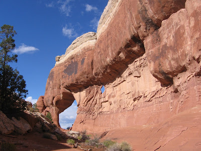
On the west side of the Cameo Cliffs there is another cove area. Along the cliff face there are several alcoves that look like arches are forming. A short distance north of the cove area there is a large alcove where an arch has formed. I think this one is known as One Eye Window.

It took me 2:25 hours of hiking to arrive at the One Eye Window. There is another old road that is not part of the marked trail system visible to the west near the arch that would allow an alternate return route for a hiker. I decided to continue north to the next trail junction with Trail 9 and complete the loop around the Cameo Cliffs.
 
The Trail 9 segment is 2 miles east and west along an area called the Cameo Terrace. The views here are north across a very scenic valley of sandstone outcrops with the LaSal Mountains in the distance. I saw a very large monolith fin near the base of the cliffs in the distance. This spectacular area is also part of the trail system. The map shows routes going to the top of the distant cliffs and on to a view point of the roadside Wilson Arch.

Trail 9 makes a junction with Trail 1 that leads back to the Hook and Ladder Trailhead in 3 miles. My total hike took 4:50 hours for about 10 miles. I hiked on a very mild 54 F degree mid December day. On the day I hiked, I didn’t see any other visitors to the area.


528614_Russell Outdoor Logo 125x125 18407_$5 Shipping on Orders of $99 or More! 544544_$20 off any hotel booking of $350 or more with code TLSALE20

Thursday, October 28, 2010

Crystal Arch-Devils Garden Trail

Crystal Arch is an easy to miss formation along the Devil’s Garden Primitive Loop in the north end of Arches National Park in southeast Utah. Look for it about 5 minutes of hiking northeast of Landscape Arch.


I didn’t see a trail leading to this fairly large arch, and wish there was one. The environment is a sandy field of Prickly Pear Cactus, Mormon Tea and another desert shrub that I think is Blackbrush.

The off trail distance is about 0.25 miles. There are small drainages to follow to avoid the biological soil crusts. The combination of fins, desert vegetation and the distant LaSal Mountains is striking.


544544_$20 off any hotel booking of $350 or more with code TLSALE20

Wednesday, October 27, 2010

Arches Windows Trail

The Windows Trail is a short 1.1 mile loop but it provides close views to three large arches and several smaller ones. The Windows Section of Arches National Park in southeast Utah is one of the most popular attractions of this other worldly park.


The trail provides an access to walk directly under the North Window. Through the window there is a good view of the Salt Valley to the north, the area that includes Delicate Arch.


 The North Window sits up high and is visible from other high viewpoints around the area, even the Antilcline Overlook at the north end of the Canyon Rims Recreation Area many miles away.
 
Just to the north of the North Window are Biceps Arch and Seagull Arch. There is a short unmarked trail to walk over and look closer. Directly under Biceps Arch a sliver of blue sky can be spotted.


Continuing around to the south is the South Window. This is also the start of the longer Windows Primitive Trail. From the Windows Primitive Trail the North and South Windows can be viewed from the opposite side. From here the trail leads back toward Turret Arch.
 

Turning back from Turret Arch, there is a good view of both Windows, a view called the Spectacles.


Looking the other way, there are the large Double Arch and the Parade of Elephants. The 0.5 mile Double Arch Trail can be easily hiked to from the Windows Trail, but most visitors move their vehicles.

(There are separate posts on Double Arch, Christmas Tree Arch, Turret Arch and the Windows Primitive Loop. Use the labels to find more pictures.)


Tuesday, October 12, 2010

Steelbender Trail

The Steelbender Trail is a multi-user trail following rocky and sandy old roads in the Mill Creek Canyon area on the southeast side of Moab in southeast Utah. The north trailhead is east on Spanish Trail Road, near the golf course and a short distance past the Golf Course petroglyph panel.

 There is a small parking area about 100 yards before the east turn on the well marked rough road. The first ten minutes of walking descends into the Mill Creek Canyon and passes through some private property. Most of the north part of the 14 miles of trail here are along the edge of the Mill Creek Canyon Wilderness Study Area.

 In the first 30 minutes of hiking there are three crossings of Mill Creek. In mid October there is a small flow and the crossings are easy. The area along the creek is lush with Cottonwood trees and willows. The canyon walls in the creek area looked like good locations for petroglyphs but I only saw a few very small figures. The trail turns left and climbs out of the canyon passing over a ledgy area that is one of the obstacles for motorized travelers.
 It took me 1:05 hours and about 2.5 miles to reach the mesa top and the junction with the loop part of the trail. The view to the east includes a rock mass that might have an arch, but it appeared to be about a mile away without an obvious trail leading over to it. I stayed on the loop trail and turned north.

 The next segment to the north has good views in all directions and there is a point where the trail splits. I stayed to the right, I think bypassing a difficult jeep obstacle. There is a small canyon crossing with more rocky ledges. The terrain here has a lot of sandstone domes and fins and the desert includes scattered Pinon Pines and Utah Junipers with Mormon Tea and Cliff Rose shrubs.

 Approaching the northwest corner of the loop, there is another junction which appears to be a shortcut. I stayed to the left. A few minutes later the main trail turns east and south, but there is a hiker trail that continues a little further north. I followed the hiker trail for about five minutes to a view point and turned around there after 2:40 hours and about 5 miles.

My return hike took 2:25 hours for a total hike of 5:05 hours for about 10 miles. It was a perfect 65 F blue sky mid October day. I saw only 3 hikers and 1 mountain biker and no vehicles during my hike. I carried and drank 3 liters of water.

Thursday, September 2, 2010

Lower Monitor and Merrimac Loop Trail

The Monitor and Merrimac (M and M) buttes are rock formations that resemble the famous battle ships of the Civil War. Most visitors to the Moab area in southeast Utah might see them from the road side viewpoint on Utah Route 313, on the way to the Island in the Sky District of Canyonlands National Park. 

There is a system of trails on the north side of the M and M buttes that can be accessed from Mill Canyon Road, a west turn just north of Mile Post 141 on Highway 191.


I started my hike at the parking area for the Mill Canyon Dinosaur Trail and hiked that short interpretive trail. At the historic Mill Canyon copper mill ruins, I continued south through the Mill Canyon riparian habitat area to the large slickrock outcrop. The Desolation Towers are visible in the distance.


The trail across the large slickrock area is well marked with painted white stripes. Part of the way across this gradually rising rocky surface, a trail junction branches to the right and leads toward the Desolation Towers. This option offers a closer approach to the Monitor and Merrimac buttes. I continued to follow the striped route of the lower loop.


The loop swings around the base of a rocky mesa with views toward M and M from about 1.5 miles away. The return leg passes by Courthouse Rock with wide views of some of the spectacular canyon country for which this area is famous. There is an option of cutting back west toward the Mill Canyon parking area or continuing north down another canyon toward the ruins of the Halfway Stage Station.


The Halfway Stage Station served travelers between Moab and the train at Thompson, Utah, 35 miles away. The normal travel time in the 1880s was 8 hours and the station was a place to have lunch, rest, and change horses. Slow moving freighters might spend the night here.


From the Halfway Stage hikers can follow about 1 mile of gravel roads back to the Dino Trail parking area. A hike could also start at the stage station and follow the M and M Loop in the clockwise direction. Not counting time on the Dino Trail, my hike took 2:15 hours for about 4.5 miles on an 82 F degree end of August day. The sky was a perfect blue and I carried 3 liters of water and drank it all.


Wednesday, September 1, 2010

Mill Canyon Dinosaur Trail

The Mill Canyon Road is a west turn off of Highway 191 just north of Mile Post 141, north of Moab in southeast Utah. After 0.6 miles there is a staging area and an information kiosk. Signs point the way another 1.1 miles to the parking area for the Dinosaur Trail

A shorter version of the Lower Monitor and Merrimac Loop bike and hiking trail can start from the same parking area. The Dino Trail is a 0.8 mile interpretive loop with many fossils visible.

The interpretive signs at the trail head mention that the deposits here are sandstones, clays and shales of the Morrison Formation from 155 to 144 million years ago. These rocks are a little younger than the Entrada Sandstone that forms most of the Arches that are famous in the area. The fossils found here include Camptosaurus, Allosaurus, Camarasaurus, and Stegosaurus.

Along the trail there are many small signs pointing out specific fossils. The directions are often very specific, such as “look four feet to your left at ground level.”

The fossils appear as purple veins in the otherwise tan and brown rocks. The fossil here is a leg bone of the 60 foot long plant eating Camarasaurus, a medium sized member of the Sauropod suborder. Further along the trail are some vertebrae from the same species.

A large petrified log is also visible along the trail. The trees in that era are described as conifers, sycamores, cypress, and yew trees.
At the far end of the loop are the ruins of the mill that Mill Canyon is named for. Copper Ore was processed here in the late 1800s. There is a black pile of smelting leftovers near the ruins. Hikers wanting to continue on the Monitor & Merrimac Loop can turn right and hike up the Mill Canyon riparian habitat area toward the Desolation Towers formation visible in the distance. Another Dinosaur trail close by is the Copper Ridge Track Way near Mile Post 148.


                                   532497_120 x 90 Starting Salary $42k. Group 1

Copper Ridge Dinosaur Tracks

The Copper Ridge Dinosaur Tracks are located east off of Highway 191, ¾ mile north of Mile Post 148, 23 miles north of Moab in southeast Utah. There isn’t a sign along the highway, but there are BLM signs saying Dinosaur Tracks-2 miles as soon as you make the turn. There is a parking area and the trail leads uphill 500 feet to the rocky small site.

The tracks preserved here are described as being from five meat eaters and one large plant eating sauropod. The tracks cross a 150 million year old river sandbar. The geologic layer is the Salt Wash member of the Morrison Formation.

The interpretive information at the site says that making plaster casts of the tracks is illegal, but sweeping the sediment off the tracks is allowed, as is pouring some water in the depressions to make them more visible for photographs. I found a brochure for the site on line but didn't find it along the trail. The brochure is helpful as it shows a map of the tracks. Looking around without a map, it is confusing what are tracks and what are natural depressions.


Some of the tracks have been surrounded with circles of stones, pointing them out. I added a liter of water to the first one. This line of four tracks, each with three toes and more than a foot long is from one of the large meat eating theropod species.


I noticed some very large depressions, but they weren’t pointed out with stone circles. The online brochure says that these are the sauropod tracks, and the huge animal was making a turn to the right. The rear feet were larger than the front feet. It looked like the depressions are about a foot deep.


Mixed in with the very large depressions are some smaller ones with more stone circle markers. These are hard to tell from natural depressions, but are thought to be from smaller meat eaters. The Copper Ridge site is in the same vicinity as the Mill Canyon Dinosaur Trail, where some fossils are visible. The other visible dinosaur track in the Moab area is at the trail head of the Poison Spider Trail along Potash Road.


  18407_$5 Shipping on Orders of $99 or More!

Tuesday, April 27, 2010

Poison Spider Trail to Little Arch

The Poison Spider Trail is a popular 4WD and mountain bike trail. For hikers, the 5.7 mile one way route to Little Arch is a good choice. The trailhead area is 6.2 miles west along Highway 279, or Potash Road on the north side of Moab in southeast Utah. The junction of Highway 279 with Highway 191 is across from the entrance to Arches National Park.


The first mile climbs with switchbacks along a road with rounded rocks. There are a couple of obstacles for vehicles that make a hiker’s progress as swift as the vehicles. In this first section there are good views across the broad slow flowing Colorado River. The total elevation gain for the trail is about 1000 feet.


On the mesa top there are domes of Navajo sandstone and desert vegetation. The walking is relatively easy on the road though there are sandy sections. Several of the desert plants are in flower in late April. There are scattered Utah Junipers and Pinon Pines, a lot of Prickly Pear Cactus, Indian Rice Grass and Pepper Grass, and Mormon Tea. I saw a few of the bright red Indian Paint Brush in bloom.

There were about a dozen 4WD vehicles on the trail the day I hiked. There were about 15 dirt bikes mostly in 3 groups, and I saw 4 mountain bikes. I was the only hiker that I saw.


The approach toward the Little Arch area has a series of sandstone domes. The trail climbs over and around the domes. It is easy to follow the burned rubber and oil spots along the rock surfaces. This area is the high cliffs that are above the Colorado River in the vicinity of the Moab Rim Trail. 

The upper part of the Moab Rim Trail and the Hidden Valley Trail can be sighted along here. Views closer to the cliffs reveal the tortured Rim Trail a very extreme route for vehicles. Watch for the junction with the Golden Spike Trail and stay to the right. There is also a loop route for vehicles that hikers would probably skip by again staying to the right.

The side route to Little Arch is well marked. For the benefit of vehicles directions are painted right on the rocks. The Little Arch is at the bottom of a deep pit and the views are from the edges. The trail head area for the Moab Rim Trail can be viewed through the arch as well as a section of river.

Among the spectacular views along the Poison Spider Trail is the many rock fins of the Behind the Rock wilderness area with the snow capped La Sal Mountains peeking above. This view is better in the afternoon as the light shifts to the west. At the trail head area there is a short trail toward a dinosaur track and petroglyphs. My hike for the 11.4 miles took 5:40 hours total on a 65 F degree blue sky late April day. I carried and drank 3 liters of water.

532497_120 x 90 Starting Salary $42k. Group 1 528614_Russell Outdoor Logo 125x125

Poison Spider Petroglyph Trail

The Poison Spider Petroglyphs are on the cliff face above the Poison Spider Trailhead and above the publicized Dinosaur Track. The trailhead is 6.2 miles west along Potash Road, Highway 279, and west of the entrance to Arches National Park in southeast Utah.


There are good views of the Colorado River from the cliffs. This site is just to the west of the extensive Indian Writing petroglyph panels that are on the Wingate Sandstone cliffs along Potash Road. The same cliff area is also very popular for rock climbing. Across the parking lot the main Poison Spider Trail begins.

The Dinosaur Track is on a flat slab of rock to the right, below the petroglyphs. The Moab Museum on Center Street has a display on fossils found in the Moab, including some reconstructed skeletons. Continue up the short marked trail to the cliffs above.

The most eye catching images to me were the line of six horned humanoids that appeared to be holding hands. There also appears to be a two headed mountain sheep and a ghostly Barrier style figure among the images. 18407_$5 Shipping on Orders of $99 or More!